Anthony Westrope, University of Missouri–Kansas City
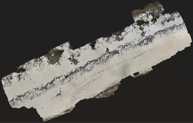
Figure 1. An orthomosaic map of the San Salvador coastline, created by stitching together hundreds of individual drone images. I’m using this composite view to identify vegetation patterns and shoreline changes linked to Hurricane Melissa.
I’m back from San Salvador Island in the Bahamas, and if fieldwork was the first half of this project, the second half is turning out to be just as demanding in a different way: taking everything I collected out in the field and turning it into a clear, organized story. Sorting and synthesizing my data has honestly become the biggest challenge of this stage. It’s one thing to fly a drone over a coastline or take a salinity reading in the sand; it’s another to sit down and make sense of what all those numbers and images are actually telling me.
A lot has shifted since I first arrived on the island, and a lot has stayed the same. My core research question hasn’t moved: I’m still investigating whether Hurricane Melissa left visible, measurable traces on San Salvador’s coastline, particularly through saltwater intrusion and its effects on coastal vegetation. What has shifted is the phase of the project. I’ve gone from planning and collecting to processing and interpreting. Instead of packing field gear, I’m now spending most of my time in front of a computer, working through drone imagery and soil salinity data to see what patterns emerge.
In terms of progress, I’d estimate I’m about 80% of the way there. The hardest parts, designing the study, collecting drone photography, gathering soil samples, and taking refractometer readings for salinity, are done. I made it through the full scientific method: asking a question, forming a hypothesis, and collecting the data needed to test it. What’s left now is finishing the details. I still need to complete the orthomosaic, which is a large, stitched-together aerial map built from hundreds of individual drone photos. I also need to compare my current images against older Google Earth imagery of the same coastline to see how the landscape has changed over time, and I need to pin down which specific visual and data indicators best support what I’m trying to show about hurricane impact on vegetation and soil.
This stage has come with real hurdles. Processing software has a learning curve, and I’ve had moments of frustration figuring out the right sequence of steps, or the right button buried in a menu, to get the program to do what I actually need. But I’ve also had genuine wins. Successfully building out a solid, organized dataset from a remote field site felt like a huge accomplishment, and every time I get a program to finally cooperate, I walk away with a new skill I didn’t have a few weeks ago.
The skills I’ve developed so far include processing environmental data using specialized computer programs, using Google Earth to compare current conditions against prior years, and applying the scientific method from start to finish in a real-world setting rather than just a classroom exercise. What I still need to work on is efficiency. I know these programs can do what I need, but I’m still learning the shortcuts and background settings that would let me work faster and with more confidence. This project has given me hands-on practice with exactly the kind of technical, data-driven skills that environmental and GIS-related employers look for, and I think that combination of field research experience and computer-based analysis will be valuable no matter which direction my career ultimately takes.
If there’s one message I’d want to share from this stage of the journey, it’s this: if you’re curious about something, go find out. Ask questions, get out there, and make the most of the time you have to explore something that genuinely interests you. My background is in psychology, not environmental science, but curiosity was enough to bring me to a small island in the Bahamas to study hurricane impacts on coastal ecosystems. You don’t need a perfectly matched resume to chase a question you care about. You just need to start.

