Every June through November, the entire state of Florida holds its breath to see if it will fall victim to a major tropical cyclone. With over 8,000 miles of coastline, Florida is one of the most vulnerable regions in the world to a hurricane or tropical storm strike; as such, the challenge of meteorologists in this state is to find new methods and tools to help keep Floridians prepared for the next storm to put a bullseye on this peninsula.
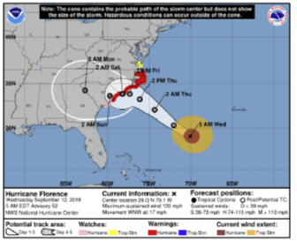
One such tool, the Cone of Uncertainty (or Cone) graphic produced by the National Hurricane Center (NHC), has been a constant feature on newscasts and preparedness websites over the past few decades whenever a tropical system has threatened Florida or other Atlantic or Gulf Coast regions. For its part, the Cone (seen below as Figure 1) does an excellent job of fulfilling its purpose of forecasting the potential track of a tropical system. The NHC has in fact been lauded in the past for its track forecast accuracy for storms that have affected all regions of the North Atlantic hurricane basin (for example, Hurricane Katrina, which the NHC was recognized for by Congress in its post-Katrina report for exemplary accuracy).
However, recent studies have suggested the purpose of the Cone graphic is not fully understood by the general population. In addition, in a worrying turn of events, some research suggests the Cone may in fact contribute to some level of unintended confusion among general viewers. Though the Cone’s primary purpose is to show the predicted track of a tropical system, there is a growing worry in the meteorology community that some members of the public may believe that the Cone depicts the region in which all effects of a tropical system (such as storm surge, high winds, and heavy rainfall) will be felt. As evidenced by the NHC’s disclaimer (seen in Figure 2 below), this belief is unfounded; tropical system-based hazards can occur outside of the cone. However, despite the inclusion of this disclaimer, there is still a significant worry that the graphic could unintentionally mislead those preparing for the impact of a tropical system into feeling a false sense of security if their city is not included directly in the cone.

As students of Florida State University’s Department of Earth, Ocean, and Atmospheric Sciences, we (Chandler Pruett and Robert Szot) have ventured to study whether such confusion is truly evident amongst the general population in Florida. In addition, we have also chosen to study potential modifications to the Cone graphic to ascertain whether an alternative may eliminate such confusion (if it exists). Over the course of Summer 2021, we will be visiting several cities in Florida to conduct in-person research to this aim (alongside conducting an online survey that will be distributed to several media partners to ensure a broad set of respondents from all backgrounds).
About the Researchers

Hailing from a suburb outside of Charlotte, North Carolina, Chandler Pruett is an undergraduate Presidential Scholar double majoring in meteorology and statistics. His interests in meteorology vary, but one phenomenon that continually grasps his interests is hurricanes. Asa hurricane analyst for Risk Management Solutions, he studies these storms as they churn across open water, putting up massive gusts of wind and stirring the seas for hundreds of miles. However, once these storms aim for the coast, his concern shifts as he remembers the images of destruction caused by Hurricanes Harvey and Florence, just to name a few. Having a secondary passion for emergency management and public safety, his eyes turn towards informing and preparing the locals, ensuring they are safe in the storm. This concern has steered his research interests, and it has guided him towards this project with the hope that better communication will yield less disaster and less lives claimed by a hurricane.
Robert Szot is an undergraduate Presidential Scholar studying meteorology from the Dallas-Fort Worth metroplex. He has been interested in both weather and communication since a young age; he attended his first Sky warn weather spotting conference during his middle school years and became a theatre and film actor when he was nine. Unifying his two interests in studying the science of communicating the weather to the public, he has become a Team Leader of the FSU Weather broadcasting program and chosen to pursue a career in either broadcast meteorology or with the National Weather Service. Both of his interests align closely with the project’s purpose — the opportunity to study how weather communication could potentially be improved was a significant pull for him to study this research topic.
